")
Since the dawn of navigation and for many centuries, the most important and busiest sea routes were located in the Mediterranean and passed through the Greek islands, connecting the West with the East.
From antiquity until the advent of ocean-going steamships, ships needed to stop frequently to refuel or to protect themselves from bad weather. Thus, nautical charts and descriptive texts were essential, providing information about ports, sheltered bays, dangerous passages and the winds they would encounter on their route.
The Greek islands, like “pebbles scattered” in the Mediterranean’s sea lanes, were constant points of reference for sailors and cartographers in the West. The ships of the European powers crossed the waters of the Ionian Islands, Crete, Euboea, the Cyclades, Lesbos, Chios, the Dodecanese and other Aegean islands on a daily basis, carrying warriors, merchandise, colonists, pilgrims, researchers, travellers and scholars. These islands served as staging and supply hubs, both in times of peace and in times of war.
Their strategic location has made them the object of careful observation, study and recording. Through the maps, not only the geography of the islands is depicted, but also their history unfolds.
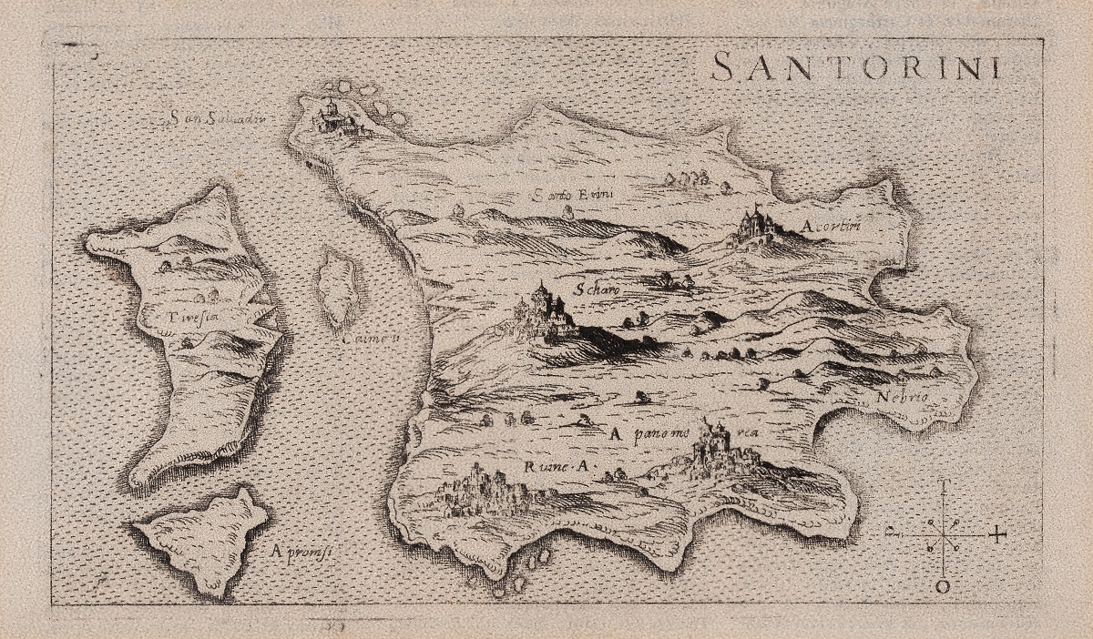
The exhibition, under the auspices of the Ministry of Merchant Shipping & Island Policy, presents a representative selection of rare nautical charts, engravings and printed portraits from the 16th to the early 19th century, from the important cartographic collection of the Maritime Museum of Greece. These are documents of not only geographical but also cultural value. They depict the Greek islands with accuracy and technical excellence and provide us with valuable information about their historical development and the conditions that shaped their unique identity. At the same time, they are works of art of their time, with impressive miniature decorations, calligraphic inscriptions, emblems and mythological motifs on their margins, which give them a special aesthetic value. Models of ships of the period, as well as some of the nautical instruments used by the captains to orient themselves at sea, frame the charts.
The exhibition also includes printed wallets, nautical aids of the 19th century from the collection of the Library “Athinoula Martinou” of the Maritime Museum of Greece. A special place is occupied by the rare edition of the portolan of Demetrios Taya – the only Greek portolan – which was first printed in Venice in the 16th century. This work is an authentic testimony to the use of practical navigation instructions, which were found in the seafaring chests of Greek ships in the pre-revolutionary period.
With the exhibition Periplus Islands, we invite you on a mental journey through time and space to discover the scientific, historical and artistic value of nautical charts that depict the history of the Greek island world.
The exhibition is financially supported by the General Secretariat for the Aegean & Island Policy.
Exhibition Opening: 19 July at 20:00
Duration: 20 July-3 August
Times: 10:00-14:00 & 18:00-21:00
Syros Merchant Marine Academy
ΕP PAPADAM 1, ERMOUPOLI, SYROS
Τel. 22810 82450


Leave A Comment